Are you curious to know what is a map grid? You have come to the right place as I am going to tell you everything about a map grid in a very simple explanation. Without further discussion let’s begin to know what is a map grid?
What Is A Map Grid?
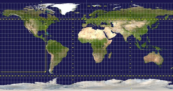
A map grid is a system of imaginary lines that are used to identify specific locations on a map. These lines are used to create a network of intersecting horizontal and vertical lines that divide a map into a series of smaller squares or rectangles. In this blog post, we’ll explore what a map grid is, how it works, and why it’s an essential tool for cartographers and anyone who uses maps.
A map grid consists of a series of intersecting horizontal and vertical lines that are drawn on a map. The lines are usually labeled with numbers or letters to create a coordinate system that can be used to identify specific locations on the map. The horizontal lines are called east-west lines, and the vertical lines are called north-south lines. The point where the two lines intersect is known as a grid point.
The most common type of map grid is the latitude and longitude grid, which uses a system of circles to divide the Earth’s surface into a series of smaller areas. The circles are called parallels, and they are drawn around the Earth’s surface parallel to the equator. The equator is the line that divides the Earth into two hemispheres, and it is used as the starting point for measuring latitude. The lines of longitude are drawn from the North Pole to the South Pole and are used to measure the distance east or west of the Prime Meridian, which is the starting point for measuring longitude.
Other types of map grids include the Universal Transverse Mercator (UTM) grid, which is used for topographic maps, and the Military Grid Reference System (MGRS), which is used by the military for navigation and targeting.
Map grids are essential tools for cartographers, surveyors, and anyone who uses maps to navigate or plan routes. They allow for precise location identification and can be used to measure distance, determine direction, and calculate elevation. Map grids are also used in GPS devices, which use satellite signals to pinpoint a user’s location on a map.
In conclusion, a map grid is a system of intersecting horizontal and vertical lines that are used to identify specific locations on a map. Map grids are essential tools for cartographers, surveyors, and anyone who uses maps to navigate or plan routes. They allow for precise location identification and can be used to measure distance, determine direction, and calculate elevation. Whether you’re exploring a new city, hiking in the wilderness, or navigating the open sea, understanding how to use a map grid can help you find your way and stay on course.
To know more about such interesting things explore queryplex
Click here – What Is Pork Cushion Meat?
FAQ
What Is The Grid On A Map Called?
The grid squares seen on a map are made up of grid lines called Eastings and Northings. Each Easting grid line is numbered west to east and the Northing grid line is numbered south to north. Eastings are the vertical lines running from top to bottom and divide the map from west to east.
What Is A Grid And What Is Its Purpose?
A grid, at least in design, is an organizational structure for arranging graphic elements, such as paragraphs, images, and infographics, on a two-dimensional surface. The goal of using a grid is to optimize your ability to communicate effectively and clearly.
What Is A Grid Short Answer?
A grid is something that is in a pattern of straight lines that cross over each other, forming squares. On maps, the grid is used to help you find a particular thing or place. …a grid of ironwork. [ + of] …a grid of narrow streets. [
Why Do We Use Map Grids?
The purpose of the grid system is to give each point in the map an identifier, an address, by which we can refer to it. Grid maps are inherently very simple and they usually use a cartesian system (X, Y system) that gives a point an X address and a Y address, resulting in an X, Y point.
How Do You Read A Map Grid?
When taking a grid reference, always read left to right along the bottom or top of the map first and then bottom to top along the side of the map. This is particularly important in an emergency situation.
What Do We Use A Map Grid To Do?
The grid helps you locate places on a map. Maps with grids have clues, and the clue for the bears is A3. Move your finger or a pointer along the lines on the map, and explain that lines on the map run across and down to form a pattern of squares. This is the grid.
What Is A 6 Grid Reference?
The grid squares on your Ordnance Survey map are all one kilometre across, which makes it easier to divide them into ten in your head. By adding an extra number (between 1 and 10) to the easting and the northing, you’ll come up with a six-figure reference that pinpoints a place to within 100 metres on the map.
Click here – What Is CIB?
I Have Covered All The Following Queries And Topics In The Above Article
What Is A Grid On A Map
What Is A Grid Map
What Is A Coordinate Grid On A Map
What Is The Distance Between Grid Lines On A Map
What Is The Definition Of A Map Grid
What Is A Map Grid Used For
What Is A Map Grid System
What Is The Grid On A Map
What Is A Grid Map Used For
What Is A Map Grid Reference
What Is A Map Grid Definition
What Are The Grid Lines On A Map Called
What Is A Map Grid In Geography
Importance Of Grid Lines On A Map
Graticule Map
What Is A Map Grid
What is grid in geography class 6